Topics still needing a figure (name could not be auto-matched — improve in scripts/build-geography-figures.js):
Eight Degree Channel · Kutch Peninsula · K2
Index by section
India · Sanctuary & Forest 1
India · Soils & Forests 2
India · Wildlife & Protected Areas 3
World · Coastal Landforms 1
World · Wildlife & Protected Areas 1
India · Maps
India — States & UTs (Political)
Added 2026-09-25
Mark in exam:- 28 states + 8 UTs
- capitals
- neighbouring countries (China / Pak / Nepal / Bangladesh / Myanmar)
- practice: redraw from a blank outline
Source: Wikimedia Commons (Planemad) · CC BY-SA 3.0
India · Maps
India — Physical Map
Added 2026-09-25
Mark in exam:- Himalayas (Great / Middle / Outer)
- Indo-Gangetic plain
- Peninsular plateau (Malwa / Deccan / Chota Nagpur)
- Vindhya–Satpura
- Western / Eastern Ghats
- coasts (Konkan / Malabar / Coromandel)
- Thar desert
- major rivers (Ganga, Yamuna, Brahmaputra, Godavari, Krishna, Narmada, Kaveri)
Source: Wikimedia Commons (Planemad) · CC BY-SA 3.0
India · Maps
India — Blank Outline (Practice Sheet)
Added 2026-09-25
Mark in exam:- trace rivers, ranges, plateaus, passes, ports on the outline
- then re-draw 2–3 examples per topic
Source: Wikimedia Commons (Planemad) · CC BY-SA 3.0
India · Geophysics
India — Seismic Zones (BIS)
Added 2026-09-25
Mark in exam:- Zone V (whole NE, Kutch, parts of J&K–Himachal, Andamans)
- Zone II (peninsular shield)
- collision front along the Himalayan arc
- Indo-Australian vs Eurasian plate boundary
Source: Wikimedia Commons (Planemad) · CC BY-SA 3.0
India · Climate
India — Southwest Monsoon Onset
Added 2026-09-25
Mark in exam:- Kerala onset (~1 June)
- Arabian Sea (Bombay) branch
- Bay of Bengal branch
- onset isochrones advancing NW
- ITCZ shift
- two branches meet over the Himalayas
Source: Wikimedia Commons (Saravask) · CC BY-SA 3.0
India · Climate
Indian Monsoon — Progress Isochrones
Added 2026-09-25
Mark in exam:- onset dates (1 June Kerala → 15 July UP/Rajasthan)
- retreat lines (Sep–Oct)
- advance (dark) vs retreat (light) isochrones
Source: Wikimedia Commons · CC BY-SA 3.0
World · Geophysics
Tectonic Plate Boundaries (World)
Added 2026-09-25
What it shows: the movement of Earth's continents relative to each other over geologic time
Mark in exam:- convergent (Himalayan front)
- divergent (Mid-Atlantic ridge, East Pacific rise)
- transform (San Andreas)
- Indian plate, Eurasian plate, Pacific ring of fire
Source: Wikimedia Commons (USGS-derived) · Public domain
World · Geophysics
Plate Boundaries — Cross-section Types
Added 2026-09-25
What it shows: a vent where molten rock, ash and gas escape from beneath the Earth’s crust
Mark in exam:- divergent → ocean-floor spreading & mid-ocean ridges
- convergent → subduction trench + volcanic arc / collision → mountains
- transform → strike-slip fault
Source: Wikimedia Commons (USGS, Jose F. Vigil) · Public domain
World · Geomorphology
Volcano — Labelled Structure
Added 2026-09-25
What it shows: a vent where molten rock, ash and gas escape from beneath the Earth’s crust
Mark in exam:- magma chamber
- conduit / pipe
- throat
- crater
- vent
- parasitic cone
- lava flow
- ash-bed layers
- flank, base, bedrock (numbered 1–15 list)
Source: Wikimedia Commons · CC BY-SA 2.5/3.0
World · Geomorphology
Stratovolcano / Composite Cone — Cross-section
Added 2026-09-25
What it shows: a vent where molten rock, ash and gas escape from beneath the Earth’s crust
Mark in exam:- alternating lava & pyroclastic layers
- central vent + conduit
- magma chamber
- side vent
- contrast: shield (Mauna Loa) v/s cinder cone
Source: Wikimedia Commons · CC BY-SA 3.0
World · Geophysics
Earthquake — Focus & Epicentre
Added 2026-09-25
Mark in exam:- focus / hypocentre (deep rupture point)
- epicentre (surface projection)
- seismic waves radiating outward
- P vs S waves
- shallow vs deep-focus zones
Source: Wikimedia Commons (deriv. of Sam Hocevar) · CC BY-SA / GFDL
World · Climate
Tropical Cyclone — Anatomy (Hurricane)
Added 2026-09-25
What it shows: a low-pressure weather system, usually spanning 1,000 kilometres (620 mi) to 2,000 kilometres (1,200 mi), in which the air circulates in a counterclockwise direction in the northern
Mark in exam:- eye (calm centre)
- eyewall (max winds)
- spiral rainbands
- outflow aloft
- anticlockwise (N-Hemisphere) due to Coriolis
- warm-core low
Source: Wikimedia Commons (Kelvinsong) · CC BY 3.0
World · Oceanography
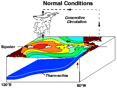
ENSO — Panel 1: Normal Conditions
Added 2026-09-25
Mark in exam:- easterly trade winds push warm pool west
- thermocline slopes down to the west
- cold upwelling off Peru / Ecuador
- rains over the warm pool (so Indonesia / Philippines)
Source: NOAA PMEL El Niño Theme Page · Public domain (US Gov)
World · Oceanography
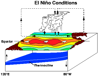
ENSO — Panel 2: El Niño
Added 2026-09-25
Mark in exam:- warm pool migrates eastwards to Central/East Pacific
- thermocline flattens
- upwelling suppressed off Peru
- weak/normal contradiction over India
- mark for UPSC: weaker monsoon over India, droughts; heavy rain on W. coast of Americas
Source: NOAA PMEL El Niño Theme Page · Public domain (US Gov)
World · Oceanography
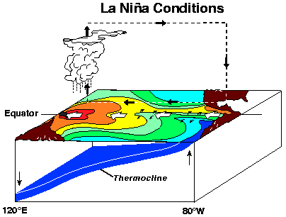
ENSO — Panel 3: La Niña
Added 2026-09-25
Mark in exam:- warm pool pushed further west
- thermocline steepens
- upwelling stronger than normal off Peru
- stronger trade winds
- often better SW monsoon & floods over India
Source: NOAA PMEL El Niño Theme Page · Public domain (US Gov)
World · Waterways
Suez Canal — Map
Added 2026-09-25
Mark in exam:- links Mediterranean (Port Said) to Red Sea (Suez)
- saves the Africa round-trip for Europe–Asia trade
- lies wholly in Egypt (Sinai to the east)
- no locks (sea-level canal)
- mark for UPSC: choke point + trade route answers
Source: Wikimedia Commons (CIA map) · Public domain
World · Waterways
Panama Canal — Map
Added 2026-09-25
Mark in exam:- links Atlantic (Colón) to Pacific (Panama City)
- saves the Cape Horn route
- locks system lifting ships to Gatun Lake
- cuts across the Isthmus of Panama
- mark the approximate lock stations
Source: Wikimedia Commons · CC BY-SA
India · Borders
India–China Border — Western Sector (Aksai Chin / Siachen)
Added 2026-09-25
What it shows: a region administered by China and constituting the easternmost portion of the larger Kashmir region that has been the subject of a border dispute between India and China since 1959
Mark in exam:- Aksai Chin region & the Karakoram Pass
- Siachen Glacier (the saltoro ridge) north flank
- Line of Actual Control (LAC) of the west
- Kashmir sector proximate to LoC with Pakistan
Source: Wikimedia Commons (CIA map, 1988) · Public domain
India · Borders
India–China Border — Eastern Sector (McMahon / Tawang)
Added 2026-09-25
What it shows: Tribal Chiefdoms The inner hill regions of present-day Arunachal Pradesh were largely outside the direct administrative control of the valley-based kingdoms of Assam and Tibet.
Mark in exam:- McMahon Line along the crest of the Himalayas
- NEFA (Arunachal) below the line
- Tawang sector (disputed; 1962 flashpoint)
- Doklam / Bhutan trijunction area (west of Tawang)
Source: Wikimedia Commons (CIA map, 1988) · Public domain
India · Borders
India 1947 — Radcliffe Line & McMahon Line (Survey of India)
Added 2026-09-25
Mark in exam:- Radcliffe Line border with Pakistan (part of today’s LoC/Wagah)
- McMahon Line border with China in the east
- borders inherited at Independence, 1947
- mark historical British-India provinces + princely states
Source: Wikimedia Commons (Survey of India) · Public domain
India · Borders
Kashmir — LoC & Siachen
Added 2026-09-25
Mark in exam:- Line of Control (India–Pakistan) dividing J&K
- Siachen Glacier to the north-east (Saltoro)
- Gilgit-Baltistan (west of LoC)
- Pok / Kargil sectors
- mark for UPSC: border-dispute + mountain-warfare answers
Source: Wikimedia Commons · CC BY-SA
India · Geomorphology
Barren Island — India’s Only Active Volcano
Added 2026-09-25
Mark in exam:- volcanic cone rising from the Andaman arc
- position in the Andaman Islands (east of the Great Andamans)
- subduction of the Indo-Australian plate under the Burma plate
- only confirmed active volcano on the South Asian mainland shelf
Source: Wikimedia Commons · Public domain
World · Geomorphology
Taal Volcano & Lake — Vicinity Map
Added 2026-09-25
What it shows: a vent where molten rock, ash and gas escape from beneath the Earth’s crust
Mark in exam:- Taal volcano island inside Taal Lake (caldera lake)
- Batangas province / Luzon position
- Caldera rim & main crater
- 2020–2022 eruption activity on the island
Source: Wikimedia Commons · CC BY-SA 3.0
World · Geomorphology
Shield Volcano — Hawaiian-Type Eruption
Added 2026-09-25
What it shows: a type of volcano named for its low profile, resembling a shield lying on the ground
Mark in exam:- broad, low-angle slopes built by fluid basaltic lava
- central summit caldera + flank rift zones
- contrast with composite cones (steep, layered)
- typical of Mauna Loa / Mauna Kea & the Deccan traps type volcanism
Source: Wikimedia Commons · CC BY-SA 4.0
India · Sanctuary & Forest
Gir Forest & Gir Somnath District — Locator
Added 2026-09-25
Mark in exam:- Gir National Park & Wildlife Sanctuary (last Asiatic lion habitat)
- Saurashtra / Gujarat location
- coastal districts around Gir Somnath
- mark for UPSC: Asiatic lion conservation + Project Lion answers
Source: Wikimedia Commons · CC BY-SA 3.0
World · Rivers
Amazon River — Basin
Added 2026-09-25
Mark in exam:- largest drainage basin on Earth
- rises in the Andes, empties into the Atlantic
- Amazon rainforest + it is the biggest river by discharge
- tributaries: Negro, Madeira, Xingu, Tapajós
Source: Wikimedia Commons · CC BY-SA 3.0
World · Rivers
Mississippi–Missouri — Basin & Watershed
Added 2026-09-25
Mark in exam:- Mississippi + Missouri + Ohio = huge US watershed
- drains ~40% of the conterminous US
- Gulf of Mexico outlet via the Mississippi Delta
- tributaries: Missouri, Ohio, Tennessee, Arkansas
Source: Wikimedia Commons · Public domain
World · Rivers
Missouri River — Basin
Added 2026-09-25
What it shows: a river in the Central and Mountain West regions of the United States
Mark in exam:- longest river in the US
- tributary of the Mississippi
- Great Plains drainage
- dams: Garrison, Oahe, Fort Peck
Source: Wikimedia Commons · CC BY-SA 4.0
World · Seas
Mediterranean Sea — Location Map
Added 2026-09-25
Mark in exam:- links Atlantic (Gibraltar strait) to Asia
- marginal seas: Adriatic, Aegean, Ionian, Black Sea via Bosporus
- Suez canal connexion to the Red Sea & Indian Ocean
- surrounding countries & the Levant coast
Source: Wikimedia Commons · CC BY-SA 3.0
World · Seas
Gulf of Mexico — Territorial Waters
Added 2026-09-25
Mark in exam:- bounded by US (Florida–Texas), Mexico, Cuba
- Yucatán Channel & Florida Strait connexions
- Loop current → Gulf Stream feeds the Atlantic
- hurricane breeding ground; oil platforms (GoM basin)
Source: Wikimedia Commons · CC BY 4.0
World · Seas
Caspian Sea — Regional Map
Added 2026-09-25
Mark in exam:- largest enclosed inland water body (Sea/Lake debate)
- borders 5 states: Russia, Iran, Azerbaijan, Kazakhstan, Turkmenistan
- Baku oil fields; Amu Darya & Volga inflow
- below sea level (Caspian Depression)
Source: Wikimedia Commons · CC BY-SA 4.0
World · Seas
Baltic Sea — Location Map
Added 2026-09-25
Mark in exam:- semi-enclosed, almost freshwater (Baltic ‘anomaly’)
- shallow, brackish, highly polluted historically
- borders: Sweden, Finland, Baltics, Poland, Germany, Russia
- connects to North Sea via Kattegat/Skagerrak
Source: Wikimedia Commons · CC BY-SA 3.0 de
World · Oceans
Atlantic Ocean — Geography
Added 2026-09-25
Mark in exam:- 2nd largest ocean; the classic S-shape between Americas & Afro-Eurasia
- Mid-Atlantic ridge (divergent boundary) in the middle
- Bermuda triangle / trade routes & Gulf Stream
- Mariana-depth: Puerto Rico Trench is the deepest Atlantic point
Source: Wikimedia Commons · Public domain
World · Oceans
Southern Ocean — Bathymetry & Islands
Added 2026-09-25
Mark in exam:- encircles Antarctica south of 60°S
- Antarctic Circumpolar Current (largest ocean current)
- no land boundary (it is a ring of ocean)
- sea ice & polar climate; Marion & Prince Edward islands
Source: Wikimedia Commons · CC BY 4.0
World · Climate
Sea Level Rise — Major Cities Threatened
Added 2026-09-25
Mark in exam:- coastal megacities exposed: Mumbai, Dhaka, Shanghai, NY, Lagos...
- delta + low-lying island states most vulnerable
- thermosteric + glacial/island ice melt contributions
- sea-level rise as a climate-change exam answer map
Source: Wikimedia Commons · CC BY-SA 3.0
World · Islands
Marshall Islands — Location Map
Added 2026-09-25
What it shows: a presidential parliamentary republic in free association with the United States, with the U
Mark in exam:- two island chains: Ratak (sunrise) & Ralik (sunset)
- atoll structure (Majuro, Kwajalein)
- US Compact / Kwajalein missile range
- climate-vulnerable low-lying atoll state
Source: Wikimedia Commons · CC BY 3.0
World · Islands
Solomon Islands — Location Map
Added 2026-09-25
Mark in exam:- archipelago east of New Guinea (Melanesia)
- Guadalcanal (WWII battle site)
- on the Pacific ring of fire (tectonically active)
- militarisation & geopolitics (2022 China security pact)
Source: Wikimedia Commons · CC BY 3.0
World · Islands
Faroe Islands — Location Map
Added 2026-09-25
Mark in exam:- 18 volcanic islands between Norway & Iceland
- autonomous territory of Denmark
- North Atlantic drift climate (mild for the latitude)
- deep fjords/fjord-like inlets & basaltic cliffs
Source: Wikimedia Commons · CC BY-SA 3.0
World · Islands
Heard Island & McDonald Islands — Sub-Antarctic Locator
Added 2026-09-25
Mark in exam:- southern Indian Ocean, ~53°S (sub-Antarctic / polar-front belt)
- Australian external territory
- Big Ben volcano → Mawson Peak (2,745 m, Australia’s highest peak)
- glaciated Laurens Peninsula; periglacial tundra climate
- no permanent population — research & conservation reserve
Source: Wikimedia Commons · CC BY-SA 3.0
World · Coastal Landforms
Coney Island — Barrier Beach (New York)
Added 2026-09-25
Mark in exam:- southern shore of Brooklyn, New York City
- sand spit / barrier beach built by longshore drift
- western end of the Rockaway–Coney barrier chain
- heavily urbanised resort & boardwalk district
- geomorphology: beach ridge vs lagoon behind
Source: Wikimedia Commons · CC BY-SA
World · Globe Concepts
Southern Hemisphere — Lambert Azimuthal View
Added 2026-09-25
Mark in exam:- lands south of the Equator (Antarctica, Australia; most of S America & southern Africa)
- seasons reversed relative to the Northern Hemisphere
- Coriolis deflects moving air LEFT → lows spin clockwise
- Southern Westerlies belt (Roaring Forties) 40–60°S
- stars: Southern Cross; polar cell & circumpolar vortex over Antarctica
Source: Wikimedia Commons · CC BY-SA
World · Wildlife & Protected Areas
National Parks of the US — Labelled by Area
Added 2026-09-25
Mark in exam:- Yellowstone 1872 = world’s first national park
- National Park Service established 1916 (Organic Act)
- 63 parks, sizes labelled (ha)
- model for IUCN Category II protected areas
- parallel: India’s national parks, tiger reserves & biosphere reserves
Source: Wikimedia Commons · CC BY-SA (derivative of NASA imagery)
World · Locator
Bay of Pigs (Bahía de Cochinos) — Cuba
Added 2026-09-25
What it shows: an inlet of the Gulf of Cazones, located on the southern coast of Cuba
Mark in exam:- bay on Cuba’s southern coast (Zapata Peninsula / Gulf of Cazones)
- site of the failed 1961 US-backed invasion
- swampy Zapata coastal plain — hindered the landing force
- Caribbean locator: Cuba 145 km from Florida
- label Havana and the US state of Florida
Source: Wikimedia Commons · CC BY-SA
India · Soils & Forests
Soils of India — Major Types (NCERT/ICAR Map)
Mark in exam:- alluvial — Indo-Gangetic plain & coasts; the largest group; khadar (new) vs bhangar (old)
- black (regur) — Deccan lava plateau; moisture-retentive, ideal for cotton
- red & yellow — crystalline Peninsular interiors; iron-oxide colouring
- laterite — alternating wet-dry tropics (Ghats, Konkan, NE); hardens on exposure
- remaining groups: arid/desert, saline-alkaline (reh, kallar), peaty, forest & mountain soils
- label one exemplar state per group (regur → Maharashtra, laterite → Kerala)
Source: Wikimedia Commons · CC BY-SA 3.0 (soil map derived from NCERT material)
India · Soils & Forests
Forest Cover of India — ISFR Density Classes
Mark in exam:- ISFR classes: very dense (>70% canopy), moderately dense (40–70%), open (10–40%); scrub recorded separately
- largest forest area: Madhya Pradesh; highest share of state area: Lakshadweep, then Mizoram
- belts to label: Western Ghats, NE states, Central Indian tribal belt, Andaman & Nicobar
- shifting cultivation & mining belts show the losses (NE + central India)
- map is a 2010 vintage — quote the latest India State of Forest Report figures in answers
Source: Wikimedia Commons · CC BY-SA 3.0 · M Tracy Hunter
India · Wildlife & Protected Areas
Biosphere Reserves of India — UNESCO Network
Mark in exam:- Nilgiri (1986) — India’s first biosphere reserve
- designation by MoEFCC under UNESCO’s Man and the Biosphere (MAB) programme
- zonation: core (legal protection) – buffer (research) – transition (settlements)
- locate: Nanda Devi, Sundarbans, Gulf of Mannar, Great Nicobar, Simlipal, Panna
- know which reserves are in the UNESCO world network vs national-only
Source: Wikimedia Commons · CC BY-SA 4.0 · MapsIntro
India · Wildlife & Protected Areas
Gir National Park — Last Home of the Asiatic Lion
Mark in exam:- the only wild population of Panthera leo persica (Asiatic lion)
- Saurashtra/Kathiawar peninsula, Gujarat (Junagadh, Gir Somnath, Amreli districts)
- sanctuary (1965) → national park (1975); core NP ~258 km² inside the wider Gir ecosystem
- dry deciduous teak–acacia forest on Deccan lava-derived soil
- differentiate Asiatic vs African lion: belly fold of skin, smaller mane
Source: Wikimedia Commons · CC BY-SA 4.0 · The Nature Box
India · Wildlife & Protected Areas
Kaziranga National Park — Brahmaputra Floodplain
What it shows: a national park and World Heritage Site in the Golaghat, Sonitpur, Biswanath and Nagaon districts of the Indian state of Assam
Mark in exam:- Assam — Golaghat, Nagaon & Sonitpur districts, south bank of the Brahmaputra
- great one-horned rhinoceros: largest remaining population; also tigers, elephants, wild buffalo
- national park 1974; UNESCO World Heritage 1985; Tiger Reserve 2006; Important Bird Area
- annual monsoon floods renew the grassland–beel wetland ecosystem
- locate the park between the Brahmaputra and the Karbi Anglong hills
Source: Wikimedia Commons · CC BY-SA 2.5
India · Maps
Airports & Major Seaports of India
Mark in exam:- west-coast ports: Kandla (Deendayal), Mumbai, JNPT, Mormugao, New Mangalore, Cochin
- east-coast ports: Kolkata–Haldia, Paradip, Visakhapatnam, Chennai, Kamarajar (Ennore), V.O. Chidambaranar (Tuticorin)
- major ports are administered centrally; others are non-major ports under state maritime boards
- note newer capacity: Vizhinjam (Kerala) & Vadhavan (Maharashtra) transhipment projects
- map is a 2010 vintage — confirm current terminals before quoting
Source: Wikimedia Commons · CC BY-SA 3.0 (2010 map)
World · Auto
Canary Islands — Suggested Figure
AUTO-SUGGESTED · verify image & labels before exam use
Added 2026-09-28
Mark in exam:- locate / label this feature plus its surrounding countries & water bodies
- state co-ordinates, hemisphere and climatic belt
- verify the image really is the feature (auto-suggested)
Source: auto-suggested from Wikimedia Commons · CC BY-SA — verify before exam
World · Auto
Long Island — Suggested Figure
AUTO-SUGGESTED · verify image & labels before exam use
Added 2026-09-28
What it shows: a densely populated continental island in southeastern New York State, extending into the Atlantic Ocean
Mark in exam:- locate / label this feature plus its surrounding countries & water bodies
- state co-ordinates, hemisphere and climatic belt
- verify the image really is the feature (auto-suggested)
Source: auto-suggested from Wikimedia Commons · CC BY-SA — verify before exam
World · Auto
Ganges river — Suggested Figure
AUTO-SUGGESTED · verify image & labels before exam use
Mark in exam:- locate / label this feature plus its surrounding countries & water bodies
- state co-ordinates, hemisphere and climatic belt
- verify the image really is the feature (auto-suggested)
Source: auto-suggested from Wikimedia Commons · CC BY-SA — verify before exam
World · Auto
Yamuna river — Suggested Figure
AUTO-SUGGESTED · verify image & labels before exam use
Mark in exam:- locate / label this feature plus its surrounding countries & water bodies
- state co-ordinates, hemisphere and climatic belt
- verify the image really is the feature (auto-suggested)
Source: auto-suggested from Wikimedia Commons · CC BY-SA — verify before exam
World · Auto
Brahmaputra river — Suggested Figure
AUTO-SUGGESTED · verify image & labels before exam use
Mark in exam:- locate / label this feature plus its surrounding countries & water bodies
- state co-ordinates, hemisphere and climatic belt
- verify the image really is the feature (auto-suggested)
Source: auto-suggested from Wikimedia Commons · CC BY-SA — verify before exam
World · Auto
Godavari river — Suggested Figure
AUTO-SUGGESTED · verify image & labels before exam use
What it shows: The Godavari River has a coverage area of 312,812 km2 (120,777 sq mi)
Mark in exam:- locate / label this feature plus its surrounding countries & water bodies
- state co-ordinates, hemisphere and climatic belt
- verify the image really is the feature (auto-suggested)
Source: auto-suggested from Wikimedia Commons · CC BY-SA — verify before exam
World · Auto
Krishna river — Suggested Figure
AUTO-SUGGESTED · verify image & labels before exam use
Mark in exam:- locate / label this feature plus its surrounding countries & water bodies
- state co-ordinates, hemisphere and climatic belt
- verify the image really is the feature (auto-suggested)
Source: auto-suggested from Wikimedia Commons · CC BY-SA — verify before exam
World · Auto
Kaveri river — Suggested Figure
AUTO-SUGGESTED · verify image & labels before exam use
Mark in exam:- locate / label this feature plus its surrounding countries & water bodies
- state co-ordinates, hemisphere and climatic belt
- verify the image really is the feature (auto-suggested)
Source: auto-suggested from Wikimedia Commons · CC BY-SA — verify before exam
World · Auto
Narmada river — Suggested Figure
AUTO-SUGGESTED · verify image & labels before exam use
What it shows: ' There are many stories about the origin of the Narmada River
Mark in exam:- locate / label this feature plus its surrounding countries & water bodies
- state co-ordinates, hemisphere and climatic belt
- verify the image really is the feature (auto-suggested)
Source: auto-suggested from Wikimedia Commons · CC BY-SA — verify before exam
World · Auto
Tapti river — Suggested Figure
AUTO-SUGGESTED · verify image & labels before exam use
Mark in exam:- locate / label this feature plus its surrounding countries & water bodies
- state co-ordinates, hemisphere and climatic belt
- verify the image really is the feature (auto-suggested)
Source: auto-suggested from Wikimedia Commons · CC BY-SA — verify before exam
World · Auto
Mahanadi river — Suggested Figure
AUTO-SUGGESTED · verify image & labels before exam use
Mark in exam:- locate / label this feature plus its surrounding countries & water bodies
- state co-ordinates, hemisphere and climatic belt
- verify the image really is the feature (auto-suggested)
Source: auto-suggested from Wikimedia Commons · CC BY-SA — verify before exam
World · Auto
Indus river — Suggested Figure
AUTO-SUGGESTED · verify image & labels before exam use
Mark in exam:- locate / label this feature plus its surrounding countries & water bodies
- state co-ordinates, hemisphere and climatic belt
- verify the image really is the feature (auto-suggested)
Source: auto-suggested from Wikimedia Commons · CC BY-SA — verify before exam
World · Auto
Sutlej river — Suggested Figure
AUTO-SUGGESTED · verify image & labels before exam use
Mark in exam:- locate / label this feature plus its surrounding countries & water bodies
- state co-ordinates, hemisphere and climatic belt
- verify the image really is the feature (auto-suggested)
Source: auto-suggested from Wikimedia Commons · CC BY-SA — verify before exam
World · Auto
Beas river — Suggested Figure
AUTO-SUGGESTED · verify image & labels before exam use
What it shows: The sugar mill has been charged a fine of ₹2.5 million (equivalent to ₹3.3 million or US$35,000 in 2023) for negligence
Mark in exam:- locate / label this feature plus its surrounding countries & water bodies
- state co-ordinates, hemisphere and climatic belt
- verify the image really is the feature (auto-suggested)
Source: auto-suggested from Wikimedia Commons · CC BY-SA — verify before exam
World · Auto
Ravi river — Suggested Figure
AUTO-SUGGESTED · verify image & labels before exam use
Mark in exam:- locate / label this feature plus its surrounding countries & water bodies
- state co-ordinates, hemisphere and climatic belt
- verify the image really is the feature (auto-suggested)
Source: auto-suggested from Wikimedia Commons · CC BY-SA — verify before exam
World · Auto
Chenab river — Suggested Figure
AUTO-SUGGESTED · verify image & labels before exam use
What it shows: a major river in India and Pakistan, and one of the five major rivers associated with the Punjab region
Mark in exam:- locate / label this feature plus its surrounding countries & water bodies
- state co-ordinates, hemisphere and climatic belt
- verify the image really is the feature (auto-suggested)
Source: auto-suggested from Wikimedia Commons · CC BY-SA — verify before exam
World · Auto
Ghaghara river — Suggested Figure
AUTO-SUGGESTED · verify image & labels before exam use
Mark in exam:- locate / label this feature plus its surrounding countries & water bodies
- state co-ordinates, hemisphere and climatic belt
- verify the image really is the feature (auto-suggested)
Source: auto-suggested from Wikimedia Commons · CC BY-SA — verify before exam
World · Auto
Kosi river — Suggested Figure
AUTO-SUGGESTED · verify image & labels before exam use
What it shows: The fury of the Kosi River left at least 2.5 million people marooned in eight districts and inundated 400 sq mi (1,000 km2)
Mark in exam:- locate / label this feature plus its surrounding countries & water bodies
- state co-ordinates, hemisphere and climatic belt
- verify the image really is the feature (auto-suggested)
Source: auto-suggested from Wikimedia Commons · CC BY-SA — verify before exam
World · Auto
Western Ghats — Suggested Figure
AUTO-SUGGESTED · verify image & labels before exam use
Mark in exam:- locate / label this feature plus its surrounding countries & water bodies
- state co-ordinates, hemisphere and climatic belt
- verify the image really is the feature (auto-suggested)
Source: auto-suggested from Wikimedia Commons · CC BY-SA — verify before exam
World · Auto
Eastern Ghats — Suggested Figure
AUTO-SUGGESTED · verify image & labels before exam use
Mark in exam:- locate / label this feature plus its surrounding countries & water bodies
- state co-ordinates, hemisphere and climatic belt
- verify the image really is the feature (auto-suggested)
Source: auto-suggested from Wikimedia Commons · CC BY-SA — verify before exam
World · Auto
Aravalli Range — Suggested Figure
AUTO-SUGGESTED · verify image & labels before exam use
Mark in exam:- locate / label this feature plus its surrounding countries & water bodies
- state co-ordinates, hemisphere and climatic belt
- verify the image really is the feature (auto-suggested)
Source: auto-suggested from Wikimedia Commons · CC BY-SA — verify before exam
World · Auto
Vindhya Range — Suggested Figure
AUTO-SUGGESTED · verify image & labels before exam use
What it shows: The Vindhya range is also called "Vindhyachala" or "Vindhyachal"; the suffix achala (Sanskrit) or achal (Hindi) refers to a mountain.
Mark in exam:- locate / label this feature plus its surrounding countries & water bodies
- state co-ordinates, hemisphere and climatic belt
- verify the image really is the feature (auto-suggested)
Source: auto-suggested from Wikimedia Commons · CC BY-SA — verify before exam
World · Auto
Satpura Range — Suggested Figure
AUTO-SUGGESTED · verify image & labels before exam use
Mark in exam:- locate / label this feature plus its surrounding countries & water bodies
- state co-ordinates, hemisphere and climatic belt
- verify the image really is the feature (auto-suggested)
Source: auto-suggested from Wikimedia Commons · CC BY-SA — verify before exam
World · Auto
Nilgiri Mountains — Suggested Figure
AUTO-SUGGESTED · verify image & labels before exam use
Mark in exam:- locate / label this feature plus its surrounding countries & water bodies
- state co-ordinates, hemisphere and climatic belt
- verify the image really is the feature (auto-suggested)
Source: auto-suggested from Wikimedia Commons · CC BY-SA — verify before exam
World · Auto
Karakoram Range — Suggested Figure
AUTO-SUGGESTED · verify image & labels before exam use
Mark in exam:- locate / label this feature plus its surrounding countries & water bodies
- state co-ordinates, hemisphere and climatic belt
- verify the image really is the feature (auto-suggested)
Source: auto-suggested from Wikimedia Commons · CC BY-SA — verify before exam
World · Auto
Pir Panjal Range — Suggested Figure
AUTO-SUGGESTED · verify image & labels before exam use
What it shows: a range of mountains in the Lower Himalayan region in the Western Himalayas of the northern South Asia
Mark in exam:- locate / label this feature plus its surrounding countries & water bodies
- state co-ordinates, hemisphere and climatic belt
- verify the image really is the feature (auto-suggested)
Source: auto-suggested from Wikimedia Commons · CC BY-SA — verify before exam
World · Auto
Zanskar Range — Suggested Figure
AUTO-SUGGESTED · verify image & labels before exam use
Mark in exam:- locate / label this feature plus its surrounding countries & water bodies
- state co-ordinates, hemisphere and climatic belt
- verify the image really is the feature (auto-suggested)
Source: auto-suggested from Wikimedia Commons · CC BY-SA — verify before exam
World · Auto
Shivalik Range — Suggested Figure
AUTO-SUGGESTED · verify image & labels before exam use
Mark in exam:- locate / label this feature plus its surrounding countries & water bodies
- state co-ordinates, hemisphere and climatic belt
- verify the image really is the feature (auto-suggested)
Source: auto-suggested from Wikimedia Commons · CC BY-SA — verify before exam
World · Auto
Deccan Plateau — Suggested Figure
AUTO-SUGGESTED · verify image & labels before exam use
What it shows: Geology The Deccan Plateau is one of the oldest and most stable land formations in the Indian subcontinent.
Mark in exam:- locate / label this feature plus its surrounding countries & water bodies
- state co-ordinates, hemisphere and climatic belt
- verify the image really is the feature (auto-suggested)
Source: auto-suggested from Wikimedia Commons · CC BY-SA — verify before exam
World · Auto
Chota Nagpur Plateau — Suggested Figure
AUTO-SUGGESTED · verify image & labels before exam use
What it shows: The total area of the Chota Nagpur Plateau is approximately 65,000 square kilometres (25,000 sq mi).
Mark in exam:- locate / label this feature plus its surrounding countries & water bodies
- state co-ordinates, hemisphere and climatic belt
- verify the image really is the feature (auto-suggested)
Source: auto-suggested from Wikimedia Commons · CC BY-SA — verify before exam
World · Auto
Marwar Plateau — Suggested Figure
AUTO-SUGGESTED · verify image & labels before exam use
Mark in exam:- locate / label this feature plus its surrounding countries & water bodies
- state co-ordinates, hemisphere and climatic belt
- verify the image really is the feature (auto-suggested)
Source: auto-suggested from Wikimedia Commons · CC BY-SA — verify before exam
World · Auto
Ladakh Plateau — Suggested Figure
AUTO-SUGGESTED · verify image & labels before exam use
Mark in exam:- locate / label this feature plus its surrounding countries & water bodies
- state co-ordinates, hemisphere and climatic belt
- verify the image really is the feature (auto-suggested)
Source: auto-suggested from Wikimedia Commons · CC BY-SA — verify before exam
World · Auto
Thar Desert — Suggested Figure
AUTO-SUGGESTED · verify image & labels before exam use
What it shows: the most widely populated desert in the world, with a population density of 83 people per km2
Mark in exam:- locate / label this feature plus its surrounding countries & water bodies
- state co-ordinates, hemisphere and climatic belt
- verify the image really is the feature (auto-suggested)
Source: auto-suggested from Wikimedia Commons · CC BY-SA — verify before exam
World · Auto
Konkan Coast — Suggested Figure
AUTO-SUGGESTED · verify image & labels before exam use
Mark in exam:- locate / label this feature plus its surrounding countries & water bodies
- state co-ordinates, hemisphere and climatic belt
- verify the image really is the feature (auto-suggested)
Source: auto-suggested from Wikimedia Commons · CC BY-SA — verify before exam
World · Auto
Malabar Coast — Suggested Figure
AUTO-SUGGESTED · verify image & labels before exam use
Mark in exam:- locate / label this feature plus its surrounding countries & water bodies
- state co-ordinates, hemisphere and climatic belt
- verify the image really is the feature (auto-suggested)
Source: auto-suggested from Wikimedia Commons · CC BY-SA — verify before exam
World · Auto
Coromandel Coast — Suggested Figure
AUTO-SUGGESTED · verify image & labels before exam use
Mark in exam:- locate / label this feature plus its surrounding countries & water bodies
- state co-ordinates, hemisphere and climatic belt
- verify the image really is the feature (auto-suggested)
Source: auto-suggested from Wikimedia Commons · CC BY-SA — verify before exam
World · Auto
Kanara Coast — Suggested Figure
AUTO-SUGGESTED · verify image & labels before exam use
Mark in exam:- locate / label this feature plus its surrounding countries & water bodies
- state co-ordinates, hemisphere and climatic belt
- verify the image really is the feature (auto-suggested)
Source: auto-suggested from Wikimedia Commons · CC BY-SA — verify before exam
World · Auto
Chilika Lake — Suggested Figure
AUTO-SUGGESTED · verify image & labels before exam use
Mark in exam:- locate / label this feature plus its surrounding countries & water bodies
- state co-ordinates, hemisphere and climatic belt
- verify the image really is the feature (auto-suggested)
Source: auto-suggested from Wikimedia Commons · CC BY-SA — verify before exam
World · Auto
Pulicat Lake — Suggested Figure
AUTO-SUGGESTED · verify image & labels before exam use
What it shows: the second-largest brackish-water lagoon in India (after Chilika Lake), measuring 759 square kilometres (293 sq mi)
Mark in exam:- locate / label this feature plus its surrounding countries & water bodies
- state co-ordinates, hemisphere and climatic belt
- verify the image really is the feature (auto-suggested)
Source: auto-suggested from Wikimedia Commons · CC BY-SA — verify before exam
World · Auto
Wular Lake — Suggested Figure
AUTO-SUGGESTED · verify image & labels before exam use
What it shows: enhanced from the Kishanganga River by the Kishanganga Hydroelectric Plant after generating electricity
Mark in exam:- locate / label this feature plus its surrounding countries & water bodies
- state co-ordinates, hemisphere and climatic belt
- verify the image really is the feature (auto-suggested)
Source: auto-suggested from Wikimedia Commons · CC BY-SA — verify before exam
World · Auto
Loktak Lake — Suggested Figure
AUTO-SUGGESTED · verify image & labels before exam use
Mark in exam:- locate / label this feature plus its surrounding countries & water bodies
- state co-ordinates, hemisphere and climatic belt
- verify the image really is the feature (auto-suggested)
Source: auto-suggested from Wikimedia Commons · CC BY-SA — verify before exam
World · Auto
Dal Lake — Suggested Figure
AUTO-SUGGESTED · verify image & labels before exam use
Mark in exam:- locate / label this feature plus its surrounding countries & water bodies
- state co-ordinates, hemisphere and climatic belt
- verify the image really is the feature (auto-suggested)
Source: auto-suggested from Wikimedia Commons · CC BY-SA — verify before exam
World · Auto
Ganges Delta — Suggested Figure
AUTO-SUGGESTED · verify image & labels before exam use
What it shows: a river delta predominantly covering the Bengal region of the Indian subcontinent, consisting of Bangladesh and the Indian state of West Bengal
Mark in exam:- locate / label this feature plus its surrounding countries & water bodies
- state co-ordinates, hemisphere and climatic belt
- verify the image really is the feature (auto-suggested)
Source: auto-suggested from Wikimedia Commons · CC BY-SA — verify before exam
World · Auto
Kaveri Delta — Suggested Figure
AUTO-SUGGESTED · verify image & labels before exam use
Mark in exam:- locate / label this feature plus its surrounding countries & water bodies
- state co-ordinates, hemisphere and climatic belt
- verify the image really is the feature (auto-suggested)
Source: auto-suggested from Wikimedia Commons · CC BY-SA — verify before exam
World · Auto
Godavari Delta — Suggested Figure
AUTO-SUGGESTED · verify image & labels before exam use
Mark in exam:- locate / label this feature plus its surrounding countries & water bodies
- state co-ordinates, hemisphere and climatic belt
- verify the image really is the feature (auto-suggested)
Source: auto-suggested from Wikimedia Commons · CC BY-SA — verify before exam
World · Auto
Sundarbans — Suggested Figure
AUTO-SUGGESTED · verify image & labels before exam use
Mark in exam:- locate / label this feature plus its surrounding countries & water bodies
- state co-ordinates, hemisphere and climatic belt
- verify the image really is the feature (auto-suggested)
Source: auto-suggested from Wikimedia Commons · CC BY-SA — verify before exam
World · Auto
Palk Strait — Suggested Figure
AUTO-SUGGESTED · verify image & labels before exam use
Mark in exam:- locate / label this feature plus its surrounding countries & water bodies
- state co-ordinates, hemisphere and climatic belt
- verify the image really is the feature (auto-suggested)
Source: auto-suggested from Wikimedia Commons · CC BY-SA — verify before exam
World · Auto
Ten Degree Channel — Suggested Figure
AUTO-SUGGESTED · verify image & labels before exam use
Mark in exam:- locate / label this feature plus its surrounding countries & water bodies
- state co-ordinates, hemisphere and climatic belt
- verify the image really is the feature (auto-suggested)
Source: auto-suggested from Wikimedia Commons · CC BY-SA — verify before exam
World · Auto
Gulf of Khambhat — Suggested Figure
AUTO-SUGGESTED · verify image & labels before exam use
What it shows: about 200 km (120 mi) long, about 20 km (12 mi) wide in the north and up to 70 km (43 mi) wide in the south
Mark in exam:- locate / label this feature plus its surrounding countries & water bodies
- state co-ordinates, hemisphere and climatic belt
- verify the image really is the feature (auto-suggested)
Source: auto-suggested from Wikimedia Commons · CC BY-SA — verify before exam
World · Auto
Gulf of Kutch — Suggested Figure
AUTO-SUGGESTED · verify image & labels before exam use
Mark in exam:- locate / label this feature plus its surrounding countries & water bodies
- state co-ordinates, hemisphere and climatic belt
- verify the image really is the feature (auto-suggested)
Source: auto-suggested from Wikimedia Commons · CC BY-SA — verify before exam
World · Auto
Gulf of Mannar — Suggested Figure
AUTO-SUGGESTED · verify image & labels before exam use
Mark in exam:- locate / label this feature plus its surrounding countries & water bodies
- state co-ordinates, hemisphere and climatic belt
- verify the image really is the feature (auto-suggested)
Source: auto-suggested from Wikimedia Commons · CC BY-SA — verify before exam
World · Auto
Kathiawar Peninsula — Suggested Figure
AUTO-SUGGESTED · verify image & labels before exam use
Mark in exam:- locate / label this feature plus its surrounding countries & water bodies
- state co-ordinates, hemisphere and climatic belt
- verify the image really is the feature (auto-suggested)
Source: auto-suggested from Wikimedia Commons · CC BY-SA — verify before exam
World · Auto
Nathu La — Suggested Figure
AUTO-SUGGESTED · verify image & labels before exam use
Mark in exam:- locate / label this feature plus its surrounding countries & water bodies
- state co-ordinates, hemisphere and climatic belt
- verify the image really is the feature (auto-suggested)
Source: auto-suggested from Wikimedia Commons · CC BY-SA — verify before exam
World · Auto
Zoji La — Suggested Figure
AUTO-SUGGESTED · verify image & labels before exam use
Mark in exam:- locate / label this feature plus its surrounding countries & water bodies
- state co-ordinates, hemisphere and climatic belt
- verify the image really is the feature (auto-suggested)
Source: auto-suggested from Wikimedia Commons · CC BY-SA — verify before exam
World · Auto
Shipki La — Suggested Figure
AUTO-SUGGESTED · verify image & labels before exam use
Mark in exam:- locate / label this feature plus its surrounding countries & water bodies
- state co-ordinates, hemisphere and climatic belt
- verify the image really is the feature (auto-suggested)
Source: auto-suggested from Wikimedia Commons · CC BY-SA — verify before exam
World · Auto
Bomdi La — Suggested Figure
AUTO-SUGGESTED · verify image & labels before exam use
Mark in exam:- locate / label this feature plus its surrounding countries & water bodies
- state co-ordinates, hemisphere and climatic belt
- verify the image really is the feature (auto-suggested)
Source: auto-suggested from Wikimedia Commons · CC BY-SA — verify before exam
World · Auto
Gangotri Glacier — Suggested Figure
AUTO-SUGGESTED · verify image & labels before exam use
Mark in exam:- locate / label this feature plus its surrounding countries & water bodies
- state co-ordinates, hemisphere and climatic belt
- verify the image really is the feature (auto-suggested)
Source: auto-suggested from Wikimedia Commons · CC BY-SA — verify before exam
World · Auto
Andaman Islands — Suggested Figure
AUTO-SUGGESTED · verify image & labels before exam use
What it shows: an archipelago, made up of 200 islands, in the northeastern Indian Ocean about 130 km (81 mi) southwest off the coasts of Myanmar's Ayeyarwady Region
Mark in exam:- locate / label this feature plus its surrounding countries & water bodies
- state co-ordinates, hemisphere and climatic belt
- verify the image really is the feature (auto-suggested)
Source: auto-suggested from Wikimedia Commons · CC BY-SA — verify before exam
World · Auto
Nicobar Islands — Suggested Figure
AUTO-SUGGESTED · verify image & labels before exam use
Mark in exam:- locate / label this feature plus its surrounding countries & water bodies
- state co-ordinates, hemisphere and climatic belt
- verify the image really is the feature (auto-suggested)
Source: auto-suggested from Wikimedia Commons · CC BY-SA — verify before exam
World · Auto
Lakshadweep — Suggested Figure
AUTO-SUGGESTED · verify image & labels before exam use
What it shows: Kalpeni and Kadamath islands as a part of the Sagar Mala project.
Mark in exam:- locate / label this feature plus its surrounding countries & water bodies
- state co-ordinates, hemisphere and climatic belt
- verify the image really is the feature (auto-suggested)
Source: auto-suggested from Wikimedia Commons · CC BY-SA — verify before exam
World · Auto
Nile river — Suggested Figure
AUTO-SUGGESTED · verify image & labels before exam use
Mark in exam:- locate / label this feature plus its surrounding countries & water bodies
- state co-ordinates, hemisphere and climatic belt
- verify the image really is the feature (auto-suggested)
Source: auto-suggested from Wikimedia Commons · CC BY-SA — verify before exam
World · Auto
Yangtze river — Suggested Figure
AUTO-SUGGESTED · verify image & labels before exam use
Mark in exam:- locate / label this feature plus its surrounding countries & water bodies
- state co-ordinates, hemisphere and climatic belt
- verify the image really is the feature (auto-suggested)
Source: auto-suggested from Wikimedia Commons · CC BY-SA — verify before exam
World · Auto
Congo river — Suggested Figure
AUTO-SUGGESTED · verify image & labels before exam use
Mark in exam:- locate / label this feature plus its surrounding countries & water bodies
- state co-ordinates, hemisphere and climatic belt
- verify the image really is the feature (auto-suggested)
Source: auto-suggested from Wikimedia Commons · CC BY-SA — verify before exam
World · Auto
Danube river — Suggested Figure
AUTO-SUGGESTED · verify image & labels before exam use
Mark in exam:- locate / label this feature plus its surrounding countries & water bodies
- state co-ordinates, hemisphere and climatic belt
- verify the image really is the feature (auto-suggested)
Source: auto-suggested from Wikimedia Commons · CC BY-SA — verify before exam
World · Auto
Rhine river — Suggested Figure
AUTO-SUGGESTED · verify image & labels before exam use
Mark in exam:- locate / label this feature plus its surrounding countries & water bodies
- state co-ordinates, hemisphere and climatic belt
- verify the image really is the feature (auto-suggested)
Source: auto-suggested from Wikimedia Commons · CC BY-SA — verify before exam
World · Auto
Volga river — Suggested Figure
AUTO-SUGGESTED · verify image & labels before exam use
Mark in exam:- locate / label this feature plus its surrounding countries & water bodies
- state co-ordinates, hemisphere and climatic belt
- verify the image really is the feature (auto-suggested)
Source: auto-suggested from Wikimedia Commons · CC BY-SA — verify before exam
World · Auto
Andes — Suggested Figure
AUTO-SUGGESTED · verify image & labels before exam use
Mark in exam:- locate / label this feature plus its surrounding countries & water bodies
- state co-ordinates, hemisphere and climatic belt
- verify the image really is the feature (auto-suggested)
Source: auto-suggested from Wikimedia Commons · CC BY-SA — verify before exam
World · Auto
Rocky Mountains — Suggested Figure
AUTO-SUGGESTED · verify image & labels before exam use
Mark in exam:- locate / label this feature plus its surrounding countries & water bodies
- state co-ordinates, hemisphere and climatic belt
- verify the image really is the feature (auto-suggested)
Source: auto-suggested from Wikimedia Commons · CC BY-SA — verify before exam
World · Auto
Ural Mountains — Suggested Figure
AUTO-SUGGESTED · verify image & labels before exam use
Mark in exam:- locate / label this feature plus its surrounding countries & water bodies
- state co-ordinates, hemisphere and climatic belt
- verify the image really is the feature (auto-suggested)
Source: auto-suggested from Wikimedia Commons · CC BY-SA — verify before exam
World · Auto
Alps — Suggested Figure
AUTO-SUGGESTED · verify image & labels before exam use
Mark in exam:- locate / label this feature plus its surrounding countries & water bodies
- state co-ordinates, hemisphere and climatic belt
- verify the image really is the feature (auto-suggested)
Source: auto-suggested from Wikimedia Commons · CC BY-SA — verify before exam
World · Auto
Himalayas — Suggested Figure
AUTO-SUGGESTED · verify image & labels before exam use
What it shows: snowbound throughout the year, in spite of their proximity to the tropics, and they form the sources of several large perennial rivers
Mark in exam:- locate / label this feature plus its surrounding countries & water bodies
- state co-ordinates, hemisphere and climatic belt
- verify the image really is the feature (auto-suggested)
Source: auto-suggested from Wikimedia Commons · CC BY-SA — verify before exam
World · Auto
Mount Everest — Suggested Figure
AUTO-SUGGESTED · verify image & labels before exam use
Mark in exam:- locate / label this feature plus its surrounding countries & water bodies
- state co-ordinates, hemisphere and climatic belt
- verify the image really is the feature (auto-suggested)
Source: auto-suggested from Wikimedia Commons · CC BY-SA — verify before exam
World · Auto
Kilimanjaro — Suggested Figure
AUTO-SUGGESTED · verify image & labels before exam use
Mark in exam:- locate / label this feature plus its surrounding countries & water bodies
- state co-ordinates, hemisphere and climatic belt
- verify the image really is the feature (auto-suggested)
Source: auto-suggested from Wikimedia Commons · CC BY-SA — verify before exam
World · Auto
Atlas Mountains — Suggested Figure
AUTO-SUGGESTED · verify image & labels before exam use
Mark in exam:- locate / label this feature plus its surrounding countries & water bodies
- state co-ordinates, hemisphere and climatic belt
- verify the image really is the feature (auto-suggested)
Source: auto-suggested from Wikimedia Commons · CC BY-SA — verify before exam
World · Auto
Appalachian Mountains — Suggested Figure
AUTO-SUGGESTED · verify image & labels before exam use
What it shows: a vast mountain range in eastern North America, extending roughly 2,050 mi (3,300 km) from central Alabama to Newfoundland along a generally southwest-northeast axis
Mark in exam:- locate / label this feature plus its surrounding countries & water bodies
- state co-ordinates, hemisphere and climatic belt
- verify the image really is the feature (auto-suggested)
Source: auto-suggested from Wikimedia Commons · CC BY-SA — verify before exam
World · Auto
Tibetan Plateau — Suggested Figure
AUTO-SUGGESTED · verify image & labels before exam use
Mark in exam:- locate / label this feature plus its surrounding countries & water bodies
- state co-ordinates, hemisphere and climatic belt
- verify the image really is the feature (auto-suggested)
Source: auto-suggested from Wikimedia Commons · CC BY-SA — verify before exam
World · Auto
Iranian Plateau — Suggested Figure
AUTO-SUGGESTED · verify image & labels before exam use
What it shows: a geological feature spanning parts of Central Asia, South Asia, West Asia, and the South Caucasus
Mark in exam:- locate / label this feature plus its surrounding countries & water bodies
- state co-ordinates, hemisphere and climatic belt
- verify the image really is the feature (auto-suggested)
Source: auto-suggested from Wikimedia Commons · CC BY-SA — verify before exam
World · Auto
Anatolian Plateau — Suggested Figure
AUTO-SUGGESTED · verify image & labels before exam use
Mark in exam:- locate / label this feature plus its surrounding countries & water bodies
- state co-ordinates, hemisphere and climatic belt
- verify the image really is the feature (auto-suggested)
Source: auto-suggested from Wikimedia Commons · CC BY-SA — verify before exam
World · Auto
Colorado Plateau — Suggested Figure
AUTO-SUGGESTED · verify image & labels before exam use
What it shows: best revealed near its southern end, where the Grand Canyon has exposed rocks with ages that span almost 2 billion years
Mark in exam:- locate / label this feature plus its surrounding countries & water bodies
- state co-ordinates, hemisphere and climatic belt
- verify the image really is the feature (auto-suggested)
Source: auto-suggested from Wikimedia Commons · CC BY-SA — verify before exam
World · Auto
Sahara Desert — Suggested Figure
AUTO-SUGGESTED · verify image & labels before exam use
Mark in exam:- locate / label this feature plus its surrounding countries & water bodies
- state co-ordinates, hemisphere and climatic belt
- verify the image really is the feature (auto-suggested)
Source: auto-suggested from Wikimedia Commons · CC BY-SA — verify before exam
World · Auto
Gobi Desert — Suggested Figure
AUTO-SUGGESTED · verify image & labels before exam use
Mark in exam:- locate / label this feature plus its surrounding countries & water bodies
- state co-ordinates, hemisphere and climatic belt
- verify the image really is the feature (auto-suggested)
Source: auto-suggested from Wikimedia Commons · CC BY-SA — verify before exam
World · Auto
Arabian Desert — Suggested Figure
AUTO-SUGGESTED · verify image & labels before exam use
What it shows: a vast desert wilderness in West Asia that occupies almost the entire Arabian Peninsula with an area of 2,330,000 square kilometers (900,000 sq mi)
Mark in exam:- locate / label this feature plus its surrounding countries & water bodies
- state co-ordinates, hemisphere and climatic belt
- verify the image really is the feature (auto-suggested)
Source: auto-suggested from Wikimedia Commons · CC BY-SA — verify before exam
World · Auto
Kalahari Desert — Suggested Figure
AUTO-SUGGESTED · verify image & labels before exam use
What it shows: a large semiarid sandy savanna in Southern Africa covering 900,000 km2 (350,000 sq mi), including much of Botswana, as well as parts of Namibia and South Africa
Mark in exam:- locate / label this feature plus its surrounding countries & water bodies
- state co-ordinates, hemisphere and climatic belt
- verify the image really is the feature (auto-suggested)
Source: auto-suggested from Wikimedia Commons · CC BY-SA — verify before exam
World · Auto
Atacama Desert — Suggested Figure
AUTO-SUGGESTED · verify image & labels before exam use
What it shows: a desert plateau on the Pacific coast of South America, stretching along a 1,600-kilometre-long (1,000-mile) strip of land in northern Chile, west of the Andes
Mark in exam:- locate / label this feature plus its surrounding countries & water bodies
- state co-ordinates, hemisphere and climatic belt
- verify the image really is the feature (auto-suggested)
Source: auto-suggested from Wikimedia Commons · CC BY-SA — verify before exam
World · Auto
Namib Desert — Suggested Figure
AUTO-SUGGESTED · verify image & labels before exam use
Mark in exam:- locate / label this feature plus its surrounding countries & water bodies
- state co-ordinates, hemisphere and climatic belt
- verify the image really is the feature (auto-suggested)
Source: auto-suggested from Wikimedia Commons · CC BY-SA — verify before exam
World · Auto
Great Victoria Desert — Suggested Figure
AUTO-SUGGESTED · verify image & labels before exam use
What it shows: a sparsely populated desert ecoregion and interim Australian bioregion in Western Australia and South Australia
Mark in exam:- locate / label this feature plus its surrounding countries & water bodies
- state co-ordinates, hemisphere and climatic belt
- verify the image really is the feature (auto-suggested)
Source: auto-suggested from Wikimedia Commons · CC BY-SA — verify before exam
World · Auto
Red Sea — Suggested Figure
AUTO-SUGGESTED · verify image & labels before exam use
Mark in exam:- locate / label this feature plus its surrounding countries & water bodies
- state co-ordinates, hemisphere and climatic belt
- verify the image really is the feature (auto-suggested)
Source: auto-suggested from Wikimedia Commons · CC BY-SA — verify before exam
World · Auto
Black Sea — Suggested Figure
AUTO-SUGGESTED · verify image & labels before exam use
Mark in exam:- locate / label this feature plus its surrounding countries & water bodies
- state co-ordinates, hemisphere and climatic belt
- verify the image really is the feature (auto-suggested)
Source: auto-suggested from Wikimedia Commons · CC BY-SA — verify before exam
World · Auto
North Sea — Suggested Figure
AUTO-SUGGESTED · verify image & labels before exam use
What it shows: In 2006 a bone fragment was found while drilling for oil in the North Sea
Mark in exam:- locate / label this feature plus its surrounding countries & water bodies
- state co-ordinates, hemisphere and climatic belt
- verify the image really is the feature (auto-suggested)
Source: auto-suggested from Wikimedia Commons · CC BY-SA — verify before exam
World · Auto
Persian Gulf — Suggested Figure
AUTO-SUGGESTED · verify image & labels before exam use
Mark in exam:- locate / label this feature plus its surrounding countries & water bodies
- state co-ordinates, hemisphere and climatic belt
- verify the image really is the feature (auto-suggested)
Source: auto-suggested from Wikimedia Commons · CC BY-SA — verify before exam
World · Auto
Caribbean Sea — Suggested Figure
AUTO-SUGGESTED · verify image & labels before exam use
Mark in exam:- locate / label this feature plus its surrounding countries & water bodies
- state co-ordinates, hemisphere and climatic belt
- verify the image really is the feature (auto-suggested)
Source: auto-suggested from Wikimedia Commons · CC BY-SA — verify before exam
World · Auto
Strait of Hormuz — Suggested Figure
AUTO-SUGGESTED · verify image & labels before exam use
Mark in exam:- locate / label this feature plus its surrounding countries & water bodies
- state co-ordinates, hemisphere and climatic belt
- verify the image really is the feature (auto-suggested)
Source: auto-suggested from Wikimedia Commons · CC BY-SA — verify before exam
World · Auto
Strait of Malacca — Suggested Figure
AUTO-SUGGESTED · verify image & labels before exam use
Mark in exam:- locate / label this feature plus its surrounding countries & water bodies
- state co-ordinates, hemisphere and climatic belt
- verify the image really is the feature (auto-suggested)
Source: auto-suggested from Wikimedia Commons · CC BY-SA — verify before exam
World · Auto
Strait of Gibraltar — Suggested Figure
AUTO-SUGGESTED · verify image & labels before exam use
What it shows: Extent The International Hydrographic Organization defines the limits of the Strait of Gibraltar as follows
Mark in exam:- locate / label this feature plus its surrounding countries & water bodies
- state co-ordinates, hemisphere and climatic belt
- verify the image really is the feature (auto-suggested)
Source: auto-suggested from Wikimedia Commons · CC BY-SA — verify before exam
World · Auto
Bering Strait — Suggested Figure
AUTO-SUGGESTED · verify image & labels before exam use
What it shows: a strait between the Pacific and Arctic oceans, separating the Chukchi Peninsula of the Russian Far East from the Seward Peninsula of Alaska
Mark in exam:- locate / label this feature plus its surrounding countries & water bodies
- state co-ordinates, hemisphere and climatic belt
- verify the image really is the feature (auto-suggested)
Source: auto-suggested from Wikimedia Commons · CC BY-SA — verify before exam
World · Auto
Bosphorus — Suggested Figure
AUTO-SUGGESTED · verify image & labels before exam use
Mark in exam:- locate / label this feature plus its surrounding countries & water bodies
- state co-ordinates, hemisphere and climatic belt
- verify the image really is the feature (auto-suggested)
Source: auto-suggested from Wikimedia Commons · CC BY-SA — verify before exam
World · Auto
Arctic Ocean — Suggested Figure
AUTO-SUGGESTED · verify image & labels before exam use
Mark in exam:- locate / label this feature plus its surrounding countries & water bodies
- state co-ordinates, hemisphere and climatic belt
- verify the image really is the feature (auto-suggested)
Source: auto-suggested from Wikimedia Commons · CC BY-SA — verify before exam
World · Auto
Indian Ocean region — Suggested Figure
AUTO-SUGGESTED · verify image & labels before exam use
Mark in exam:- locate / label this feature plus its surrounding countries & water bodies
- state co-ordinates, hemisphere and climatic belt
- verify the image really is the feature (auto-suggested)
Source: auto-suggested from Wikimedia Commons · CC BY-SA — verify before exam
World · Auto
Pacific Ocean region — Suggested Figure
AUTO-SUGGESTED · verify image & labels before exam use
Mark in exam:- locate / label this feature plus its surrounding countries & water bodies
- state co-ordinates, hemisphere and climatic belt
- verify the image really is the feature (auto-suggested)
Source: auto-suggested from Wikimedia Commons · CC BY-SA — verify before exam
World · Auto
Lake Baikal — Suggested Figure
AUTO-SUGGESTED · verify image & labels before exam use
What it shows: Lake Baikal is a rift lake and the deepest lake in the world
Mark in exam:- locate / label this feature plus its surrounding countries & water bodies
- state co-ordinates, hemisphere and climatic belt
- verify the image really is the feature (auto-suggested)
Source: auto-suggested from Wikimedia Commons · CC BY-SA — verify before exam
World · Auto
Lake Victoria — Suggested Figure
AUTO-SUGGESTED · verify image & labels before exam use
Mark in exam:- locate / label this feature plus its surrounding countries & water bodies
- state co-ordinates, hemisphere and climatic belt
- verify the image really is the feature (auto-suggested)
Source: auto-suggested from Wikimedia Commons · CC BY-SA — verify before exam
World · Auto
Lake Tanganyika — Suggested Figure
AUTO-SUGGESTED · verify image & labels before exam use
Mark in exam:- locate / label this feature plus its surrounding countries & water bodies
- state co-ordinates, hemisphere and climatic belt
- verify the image really is the feature (auto-suggested)
Source: auto-suggested from Wikimedia Commons · CC BY-SA — verify before exam
World · Auto
Lake Titicaca — Suggested Figure
AUTO-SUGGESTED · verify image & labels before exam use
Mark in exam:- locate / label this feature plus its surrounding countries & water bodies
- state co-ordinates, hemisphere and climatic belt
- verify the image really is the feature (auto-suggested)
Source: auto-suggested from Wikimedia Commons · CC BY-SA — verify before exam
World · Auto
Dead Sea — Suggested Figure
AUTO-SUGGESTED · verify image & labels before exam use
Mark in exam:- locate / label this feature plus its surrounding countries & water bodies
- state co-ordinates, hemisphere and climatic belt
- verify the image really is the feature (auto-suggested)
Source: auto-suggested from Wikimedia Commons · CC BY-SA — verify before exam
World · Auto
Great Lakes region — Suggested Figure
AUTO-SUGGESTED · verify image & labels before exam use
What it shows: The Great Lakes region of Northern America is a binational Canadian–American region centered on the Great Lakes that includes the U.S
Mark in exam:- locate / label this feature plus its surrounding countries & water bodies
- state co-ordinates, hemisphere and climatic belt
- verify the image really is the feature (auto-suggested)
Source: auto-suggested from Wikimedia Commons · CC BY-SA — verify before exam
World · Auto
Pantanal — Suggested Figure
AUTO-SUGGESTED · verify image & labels before exam use
What it shows: water quality in the Pantanal was not significantly degraded as of 2002.
Mark in exam:- locate / label this feature plus its surrounding countries & water bodies
- state co-ordinates, hemisphere and climatic belt
- verify the image really is the feature (auto-suggested)
Source: auto-suggested from Wikimedia Commons · CC BY-SA — verify before exam
World · Auto
Okavango Delta — Suggested Figure
AUTO-SUGGESTED · verify image & labels before exam use
Mark in exam:- locate / label this feature plus its surrounding countries & water bodies
- state co-ordinates, hemisphere and climatic belt
- verify the image really is the feature (auto-suggested)
Source: auto-suggested from Wikimedia Commons · CC BY-SA — verify before exam
World · Auto
Equator — Suggested Figure
AUTO-SUGGESTED · verify image & labels before exam use
What it shows: the circle of latitude that divides Earth into the Northern and Southern Hemispheres
Mark in exam:- locate / label this feature plus its surrounding countries & water bodies
- state co-ordinates, hemisphere and climatic belt
- verify the image really is the feature (auto-suggested)
Source: auto-suggested from Wikimedia Commons · CC BY-SA — verify before exam
World · Auto
Tropic of Cancer — Suggested Figure
AUTO-SUGGESTED · verify image & labels before exam use
What it shows: currently drifting southward at a rate of almost half an arcsecond (0
Mark in exam:- locate / label this feature plus its surrounding countries & water bodies
- state co-ordinates, hemisphere and climatic belt
- verify the image really is the feature (auto-suggested)
Source: auto-suggested from Wikimedia Commons · CC BY-SA — verify before exam
World · Auto
Tropic of Capricorn — Suggested Figure
AUTO-SUGGESTED · verify image & labels before exam use
What it shows: the circle of latitude that contains the subsolar point at the December solstice
Mark in exam:- locate / label this feature plus its surrounding countries & water bodies
- state co-ordinates, hemisphere and climatic belt
- verify the image really is the feature (auto-suggested)
Source: auto-suggested from Wikimedia Commons · CC BY-SA — verify before exam
World · Auto
Arctic Circle — Suggested Figure
AUTO-SUGGESTED · verify image & labels before exam use
What it shows: one of the two polar circles, and the northernmost of the five major circles of latitude
Mark in exam:- locate / label this feature plus its surrounding countries & water bodies
- state co-ordinates, hemisphere and climatic belt
- verify the image really is the feature (auto-suggested)
Source: auto-suggested from Wikimedia Commons · CC BY-SA — verify before exam
World · Auto
Antarctic Circle — Suggested Figure
AUTO-SUGGESTED · verify image & labels before exam use
Mark in exam:- locate / label this feature plus its surrounding countries & water bodies
- state co-ordinates, hemisphere and climatic belt
- verify the image really is the feature (auto-suggested)
Source: auto-suggested from Wikimedia Commons · CC BY-SA — verify before exam
World · Auto
Jet stream — Suggested Figure
AUTO-SUGGESTED · verify image & labels before exam use
What it shows: closely linked to the frontogenesis process in midlatitudes, as the acceleration/deceleration of the air flow induces areas of low/high pressure respectively, which link to the
Mark in exam:- locate / label this feature plus its surrounding countries & water bodies
- state co-ordinates, hemisphere and climatic belt
- verify the image really is the feature (auto-suggested)
Source: auto-suggested from Wikimedia Commons · CC BY-SA — verify before exam
World · Auto
Tornado — Suggested Figure
AUTO-SUGGESTED · verify image & labels before exam use
Mark in exam:- locate / label this feature plus its surrounding countries & water bodies
- state co-ordinates, hemisphere and climatic belt
- verify the image really is the feature (auto-suggested)
Source: auto-suggested from Wikimedia Commons · CC BY-SA — verify before exam
World · Auto
Coriolis effect — Suggested Figure
AUTO-SUGGESTED · verify image & labels before exam use
Mark in exam:- locate / label this feature plus its surrounding countries & water bodies
- state co-ordinates, hemisphere and climatic belt
- verify the image really is the feature (auto-suggested)
Source: auto-suggested from Wikimedia Commons · CC BY-SA — verify before exam
World · Auto
ITCZ — Suggested Figure
AUTO-SUGGESTED · verify image & labels before exam use
Mark in exam:- locate / label this feature plus its surrounding countries & water bodies
- state co-ordinates, hemisphere and climatic belt
- verify the image really is the feature (auto-suggested)
Source: auto-suggested from Wikimedia Commons · CC BY-SA — verify before exam
World · Auto
Mid-Atlantic Ridge — Suggested Figure
AUTO-SUGGESTED · verify image & labels before exam use
What it shows: a mid-ocean ridge (a divergent or constructive plate boundary) located along the floor of the Atlantic Ocean, and part of the longest mountain range in the world
Mark in exam:- locate / label this feature plus its surrounding countries & water bodies
- state co-ordinates, hemisphere and climatic belt
- verify the image really is the feature (auto-suggested)
Source: auto-suggested from Wikimedia Commons · CC BY-SA — verify before exam
World · Auto
Pacific Ring of Fire — Suggested Figure
AUTO-SUGGESTED · verify image & labels before exam use
Mark in exam:- locate / label this feature plus its surrounding countries & water bodies
- state co-ordinates, hemisphere and climatic belt
- verify the image really is the feature (auto-suggested)
Source: auto-suggested from Wikimedia Commons · CC BY-SA — verify before exam
World · Auto
Plate boundary types — Suggested Figure
AUTO-SUGGESTED · verify image & labels before exam use
Mark in exam:- locate / label this feature plus its surrounding countries & water bodies
- state co-ordinates, hemisphere and climatic belt
- verify the image really is the feature (auto-suggested)
Source: auto-suggested from Wikimedia Commons · CC BY-SA — verify before exam
World · Auto
Fold mountain — Suggested Figure
AUTO-SUGGESTED · verify image & labels before exam use
Mark in exam:- locate / label this feature plus its surrounding countries & water bodies
- state co-ordinates, hemisphere and climatic belt
- verify the image really is the feature (auto-suggested)
Source: auto-suggested from Wikimedia Commons · CC BY-SA — verify before exam
World · Auto
Block mountain — Suggested Figure
AUTO-SUGGESTED · verify image & labels before exam use
Mark in exam:- locate / label this feature plus its surrounding countries & water bodies
- state co-ordinates, hemisphere and climatic belt
- verify the image really is the feature (auto-suggested)
Source: auto-suggested from Wikimedia Commons · CC BY-SA — verify before exam
World · Auto
Rift valley — Suggested Figure
AUTO-SUGGESTED · verify image & labels before exam use
Mark in exam:- locate / label this feature plus its surrounding countries & water bodies
- state co-ordinates, hemisphere and climatic belt
- verify the image really is the feature (auto-suggested)
Source: auto-suggested from Wikimedia Commons · CC BY-SA — verify before exam
World · Auto
Alluvial plain — Suggested Figure
AUTO-SUGGESTED · verify image & labels before exam use
Mark in exam:- locate / label this feature plus its surrounding countries & water bodies
- state co-ordinates, hemisphere and climatic belt
- verify the image really is the feature (auto-suggested)
Source: auto-suggested from Wikimedia Commons · CC BY-SA — verify before exam
World · Auto
River delta formation — Suggested Figure
AUTO-SUGGESTED · verify image & labels before exam use
Mark in exam:- locate / label this feature plus its surrounding countries & water bodies
- state co-ordinates, hemisphere and climatic belt
- verify the image really is the feature (auto-suggested)
Source: auto-suggested from Wikimedia Commons · CC BY-SA — verify before exam
World · Auto
Glacial landforms — Suggested Figure
AUTO-SUGGESTED · verify image & labels before exam use
Mark in exam:- locate / label this feature plus its surrounding countries & water bodies
- state co-ordinates, hemisphere and climatic belt
- verify the image really is the feature (auto-suggested)
Source: auto-suggested from Wikimedia Commons · CC BY-SA — verify before exam
World · Auto
Karst topography — Suggested Figure
AUTO-SUGGESTED · verify image & labels before exam use
Mark in exam:- locate / label this feature plus its surrounding countries & water bodies
- state co-ordinates, hemisphere and climatic belt
- verify the image really is the feature (auto-suggested)
Source: auto-suggested from Wikimedia Commons · CC BY-SA — verify before exam
World · Auto
Loess plateau — Suggested Figure
AUTO-SUGGESTED · verify image & labels before exam use
Mark in exam:- locate / label this feature plus its surrounding countries & water bodies
- state co-ordinates, hemisphere and climatic belt
- verify the image really is the feature (auto-suggested)
Source: auto-suggested from Wikimedia Commons · CC BY-SA — verify before exam
World · Auto
Cirque and arete — Suggested Figure
AUTO-SUGGESTED · verify image & labels before exam use
Mark in exam:- locate / label this feature plus its surrounding countries & water bodies
- state co-ordinates, hemisphere and climatic belt
- verify the image really is the feature (auto-suggested)
Source: auto-suggested from Wikimedia Commons · CC BY-SA — verify before exam
World · Auto
Mangrove forest — Suggested Figure
AUTO-SUGGESTED · verify image & labels before exam use
Mark in exam:- locate / label this feature plus its surrounding countries & water bodies
- state co-ordinates, hemisphere and climatic belt
- verify the image really is the feature (auto-suggested)
Source: auto-suggested from Wikimedia Commons · CC BY-SA — verify before exam
World · Auto
Great Barrier Reef — Suggested Figure
AUTO-SUGGESTED · verify image & labels before exam use
Mark in exam:- locate / label this feature plus its surrounding countries & water bodies
- state co-ordinates, hemisphere and climatic belt
- verify the image really is the feature (auto-suggested)
Source: auto-suggested from Wikimedia Commons · CC BY-SA — verify before exam
World · Auto
Galapagos Islands — Suggested Figure
AUTO-SUGGESTED · verify image & labels before exam use
Mark in exam:- locate / label this feature plus its surrounding countries & water bodies
- state co-ordinates, hemisphere and climatic belt
- verify the image really is the feature (auto-suggested)
Source: auto-suggested from Wikimedia Commons · CC BY-SA — verify before exam
World · Auto
Maldives — Suggested Figure
AUTO-SUGGESTED · verify image & labels before exam use
Mark in exam:- locate / label this feature plus its surrounding countries & water bodies
- state co-ordinates, hemisphere and climatic belt
- verify the image really is the feature (auto-suggested)
Source: auto-suggested from Wikimedia Commons · CC BY-SA — verify before exam
World · Auto
Hawaiian Islands — Suggested Figure
AUTO-SUGGESTED · verify image & labels before exam use
What it shows: an archipelago of eight major volcanic islands, several atolls, and numerous smaller islets in the North Pacific Ocean, extending some 1,300 nautical miles (1,500 miles
Mark in exam:- locate / label this feature plus its surrounding countries & water bodies
- state co-ordinates, hemisphere and climatic belt
- verify the image really is the feature (auto-suggested)
Source: auto-suggested from Wikimedia Commons · CC BY-SA — verify before exam
World · Auto
Krakatoa — Suggested Figure
AUTO-SUGGESTED · verify image & labels before exam use
Mark in exam:- locate / label this feature plus its surrounding countries & water bodies
- state co-ordinates, hemisphere and climatic belt
- verify the image really is the feature (auto-suggested)
Source: auto-suggested from Wikimedia Commons · CC BY-SA — verify before exam
World · Auto
Mount Vesuvius — Suggested Figure
AUTO-SUGGESTED · verify image & labels before exam use
Mark in exam:- locate / label this feature plus its surrounding countries & water bodies
- state co-ordinates, hemisphere and climatic belt
- verify the image really is the feature (auto-suggested)
Source: auto-suggested from Wikimedia Commons · CC BY-SA — verify before exam
World · Auto
Mount Fuji — Suggested Figure
AUTO-SUGGESTED · verify image & labels before exam use
Mark in exam:- locate / label this feature plus its surrounding countries & water bodies
- state co-ordinates, hemisphere and climatic belt
- verify the image really is the feature (auto-suggested)
Source: auto-suggested from Wikimedia Commons · CC BY-SA — verify before exam
World · Auto
Mount Etna — Suggested Figure
AUTO-SUGGESTED · verify image & labels before exam use
Mark in exam:- locate / label this feature plus its surrounding countries & water bodies
- state co-ordinates, hemisphere and climatic belt
- verify the image really is the feature (auto-suggested)
Source: auto-suggested from Wikimedia Commons · CC BY-SA — verify before exam
World · Auto
Rainfall distribution of India — Suggested Figure
AUTO-SUGGESTED · verify image & labels before exam use
Mark in exam:- locate / label this feature plus its surrounding countries & water bodies
- state co-ordinates, hemisphere and climatic belt
- verify the image really is the feature (auto-suggested)
Source: auto-suggested from Wikimedia Commons · CC BY-SA — verify before exam
World · Auto
Flood prone areas of India — Suggested Figure
AUTO-SUGGESTED · verify image & labels before exam use
Mark in exam:- locate / label this feature plus its surrounding countries & water bodies
- state co-ordinates, hemisphere and climatic belt
- verify the image really is the feature (auto-suggested)
Source: auto-suggested from Wikimedia Commons · CC BY-SA — verify before exam
World · Auto
Andaman Sea — Suggested Figure
AUTO-SUGGESTED · verify image & labels before exam use
What it shows: The fishery and tourist infrastructure was severely damaged by the December 2004 Indian Ocean earthquake and tsunami.
Mark in exam:- locate / label this feature plus its surrounding countries & water bodies
- state co-ordinates, hemisphere and climatic belt
- verify the image really is the feature (auto-suggested)
Source: auto-suggested from Wikimedia Commons · CC BY-SA — verify before exam
vlymbooq